Does anyone have experience using the Rick steves europe planning map in more rural areas or smaller towns? Is it detailed enough for places outside major cities or if an additional local map might be necessary. If any of you is going there, take your dog along, or he can show you the side eye.
Are you referring to the RAILWAY maps on this page?
https://www.ricksteves.com/travel-tips/transportation/trains/cost-maps
The fares shown estimate one-way, walk-up fares (at the highest possible price) for comparison with railpass costs; NOT shown are the many discount options for those one-way fares, or the normal day pass options, or the month-long tickets that you can take advantage of just like normal citizens do.
The maps show only a small fraction of the actual train routes... which are the ones that tend to serve smaller towns; compare the Rick Steves map for Germany with the detailed map below for Germany to see what I mean.
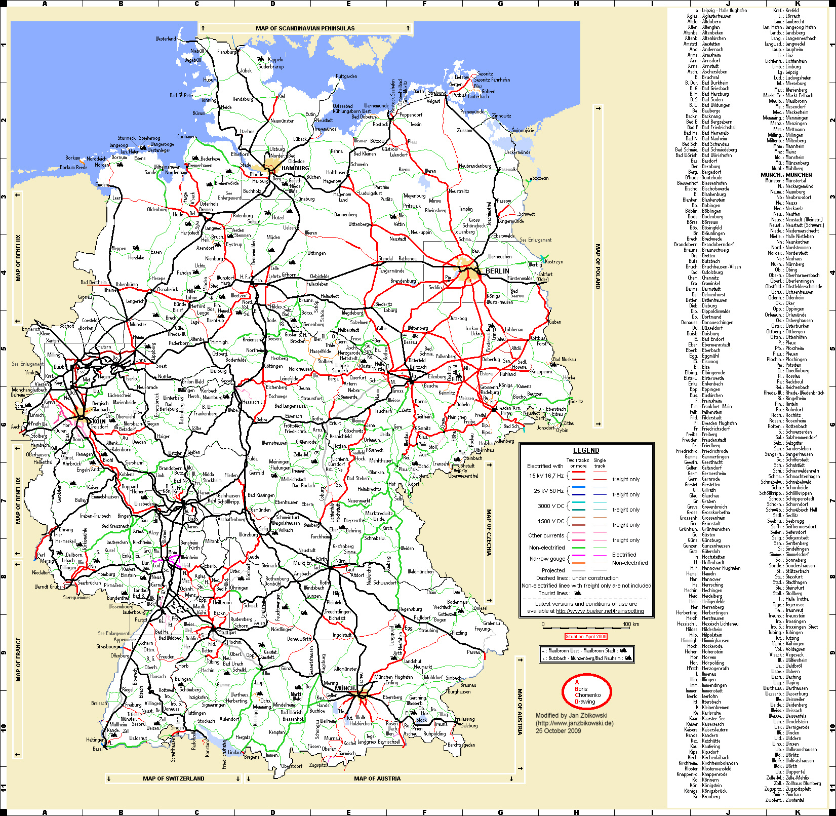
Thanks for the info! i am referring to the Rick steves europe planning map, not the railway maps specifically. The question is about the level of detail on that map for smaller towns and rural areas outside of major cities. Do you think it’s comprehensive enough for general trip planning, or would you recommend getting a more detailed local map if plan on spending time outside the usual tourist spots?
Are you driving? If so, then no, it's not detailed enough, IMO.
I used it for planning a general itinerary for my trip to Europe several years ago which involved travel from Brussels to cities in Germany, Ausria, Czechia, Poland, and Hungary. It's good for getting an idea of which cities are well connected by rail, which is what I was planning. It's not detailed enough to cover small towns and countryside visits or for driving itineraries. For that you need more detailed maps of the specific area you are staying in and around. For driving around France on a previous trip I relied on Michelin maps for the individual regions of the country - Brittany, Normandy, Provence, etc..
Alr guys, tysm for your time!
This ?
https://store.ricksteves.com/shop/p/europe-travel-map
Printed on tough, water-resistant paper
Perfect for pre-trip planning
Designed by travelers
Includes freeways and main train lines
Eight city-center maps on reverse side
Have not seen it, but suspect it useful to show where places are in relation to the main cities, but probably not enough detail to use for navigation.
Thanks for the info! i am referring to the Rick steves europe planning map, not the railway maps specifically. The question is about the level of detail on that map for smaller towns and rural areas outside of major cities. Do you think it’s comprehensive enough for general trip planning, or would you recommend getting a more detailed local map if plan on spending time outside the usual tourist spots?
His maps are no different to any other large scale maps of Europe, they will give you a good idea of what is out there, but you need more detailed maps when on the ground.
At this stage most countries have made their Ordnance Survey maps available for free via an app and it is a good idea to use these. Here for example is the link for the Swiss ones:
oddfinnoliver,
I second Nancy about the Michelin maps. We get the ones for each region we visit and can use them to oversee where we are and where we would like to go. They are much better for determining our route and , of course, show all the towns in a department or province. Plus, I mark our route on them and they become a souvenir of that trip. You can order them from Amazon for about the same price as in a bookstore such as Barnes and Noble. I don't know if they make ones for other countries.
(Just looking at them before we depart for a trip sets my senses tingling about the villages we will go through and the scenery we will see!)